 Live Music Archive
 Librivox Free Audio
 Metropolitan Museum
 Cleveland Museum of Art
 Internet Arcade
 Console Living Room
 Books to Borrow
 Open Library
 TV News
 Understanding 9/11
tv 9 News Now at 6am CBS November 1, 2012 6:00am-7:00am EDT
6:00 am

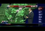
through the weekend. sandy is keeping it a little bit -- us a little bit cloudy and cool. we should be in low 60s for highs for the beginning of november and only going to be in the mid 50s. i think a lot of people will be catching up on sleep as we get into the weekend. >> that extra hour. >> extra hour of sleep saturday night turning the clocks back. noon 52 and cloudy to mostly cloudy. a little bit breezy at times this afternoon. we're sitting at 9 in manassas and -- 39 in manassas and 46 up in baltimore. and annapolis. and 39 also across the bay in cambridge. one of the cooler spots but winds not too strong this morning so the windchills within that much lower than -- aren't that much lower than the actual temperatures upper 30s to low 40s. the bark worse than the bite on the radar here and we still have some areas of snow also at the higher elevations and some of those folks got over 30 inches of snow incredible storm that sandy was. and we're going to be recovering from sandy across east for quite some sometime. let's they can in with sam -- check in with monika samtani
6:01 am

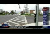
here with timesaver traffic. georgetown pike just west of the beltway at georgetown court potential wires down. don't know about lane close yours right now -- closures right now but watch out for the activity just west of the beltway. metro orange line delays at new carolton because of earlier power problems. and penn 401 is running ten minutes late. what it looks like. first of all on the northbound side of 395 here at the 14th street bridge, no issues right now from the beltway. in delays to this point. and into the downtown area. one more last live look outside if you're planning to head here on the beltway at bradley boulevard, bethesda, this is a good indication of the entire western stretch of the beltway through tysons corner and beyond. i'll be back with more traffic coming up in my next report. back to you guys. a show recovery begins from -- slow recovery begins if superstorm sandy. the u.s. death toll is now at 64. the estimates of destruction and economic fallout are running around $55 billion.
6:02 am

a part of new york's subway system is expected to be in operation today and once submerged laguardia airport will reopen at 7:00 with very limited service. >> much lower manhattan though is still in the dark. thousands of residents in hoboken new jersey across the river from manhattan have been given ready to eat meals and other supplies from the national guard. along the new jersey shore, president obama and governor chris christie took a helicopter hour of the storm damage because that's the only way to see it. >> kristin fisher is here with us this morning and kristin, you were out in the field. you were in rehoboth. and just give us an idea again of what you saw and what's going on now. >> reporter: well, it's tough to compare the two because what i found in rehoboth is nothing compared to what we're now seeing in new york and new jersey with you know, up and down the coast. millions of people remaining in the dark. the damage in the billions of dollars. and the death toll now at least 63 people. yesterday president obama brought some hope to hard hit new jersey, promising immediate
6:03 am

federal aid and pledging to be in its for the lang howl. he -- long haul. he toured the garden state with governor chris christie with entire neighborhoods still underwater. the president said the top priority is getting the power back on especially atwater filtration plants and other critical infrastructure. the second priority? transportation. clearing the roads from debris and restoring mass transit so people can go back to work and their kids can finally go back to school. >> we are here for you. and we will not forget. we will follow-up to make sure that you get all the help that you need until you've rebuilt. we want to make sure that people have realistic expectations but i can promise you the federal government will be working as closely as possible with the state and local officials and we won't quit until this is done. >> reporter: i think this image is probably the one that sticks with me the most. just home after home buried in sand.
6:04 am

entire neighborhoods completely wiped out. and for the people who live there, it's slowly sinking in that everything in these coastal communities that they've grown to love, it's all going to have to be rebuilt but safety first. and in most of these coastal communities every city you go to, city after city, all you can hear is the hissing of natural gas. residents there very concerned about the chance for even more fires and we've already seen how bad that can be in new york city. we'll have more on that destruction there especially in the breezy point neighborhood coming up at 6:30. >> we were talking -- you can't even get trailers for people to stay in as temporary housing because there's no infrastructure and you've got to clear away all of that debris. >> reporter: yeah and in lower manhattan most of the roads are still completely flooded with water. they have to pump it all out. it's crazy. you can really understand why sandy is now being called new jersey and new york's katrina. >> it's big deal. >> thanks christine. here's a look at the latest outage numbers in our area --
6:05 am

this morning, police continue to investigate a fatal pedestrian accident in jermantown. sky 9 was over the scene yesterday when a 15-year-old was killed on jermantown road at wisteria drive. the victim has been identified as christina morris-ward. she was a tenth grader at seneca valley high school and he was walking to -- she was walking to school. julie wolf excuse me is live on the scene in jermantown and she has more on where things are moving forward today. julie, good morning. >> reporter: good morning to you mike, we are here less than a half a mile from seneca value legal high school. this is where christina morris- ward was trying to cross the road and make it here on the
6:06 am

way to school when she was hit and killed. montgomery county police tell me they are still reconstructing the accident. here at the scene yesterday, they told me that the driver did stop to help after the accident. and he was the one with the green light. the principal at seneca valley high school told me this is a common walking route to school and even christina's best friend walks this same route every day. the 15-year-old is described as the kind of girl that gaslights audiotape room. -- just lights up a room. >> she was just a very happ individual. >> i mean it's sad because that's my best friend. i didn't want her to go. it hurts. hurts a lot. it hurts having her at my house, me going over to her house. everything. >> reporter: now, you can see the intersection behind me, the
6:07 am

lights are working. i specifically asked the police about that. they said the lights were in working order when this happened yesterday. but as it is dark now it was also dark at the time of the accident. and in fact sunrise is not until 7:35 this morning. police say they want seneca valley high school students any walking students to wear something with reflection on it. this is a safety vest that our crews use but even they say if you can wear one of these kinds of reflective pieces of tape something on the body, anything they say to make yourself more visible. something seneca valley high school will be talking about in the days to come. more from their principal in the next half hour. julie wolf. 9news now. at 6:07. jessica doyle is here and she is watching your money. >> and she's also watching your smart phone after sandy. >> that's right. now if you've had problems with your cell phone after hurricane sandy, you are far from alone. the cell companies are still working to get the power back on to a quarter of their cell towers and resume broadband,
6:08 am

internet and television services. the head of the fcc says cell service is only going to get worse before it gets better. many towers have been running on backup battery power fueled by generators but crews are having trouble getting to the generators because of the flooding and once the generators go down the batteries die and additional towers are expected to go dark. in the meantime, questions are being raised if the federal emergency management agency or fema has enough money on hand to cover flood damage if the storm. flood damage alone is estimated in the billions of dollars and fema runs the federal flood insurance program so it picks up the tab. insurance experts say fema's flood insurance program has access to funds totaling less than $4 billion, most of that is in loans and cnn reports fema already owes $18 billion to the treasury department they say all the way back to hurricane katrina. that's a problem. the pharmaceutical industry is activated an emergency website to help patients
6:09 am

affected by sandy find nearby pharmacies that are open. the pharmacy statuses that called rx response has been activated in d.c., maryland and virginia and nine other states with widespread power outages many pharmacies have been unable to open and of course we've seen the delivery of supplies such as drug supplies being disrupted. it may not be the situation that your pharmacy hasn't even been open. they can't even get the trucks in to get your necessary medication. so this service should help people find what they need in these really terrible times. this has been a rough week for a lot of people. >> how interconnected we are too. sandy caused a lot of devastation as you've been hearing and there are a lot of people all over the coast who need help. >> here at wusa9 we're donating $1 to the american red cross sandy relief fund for any one of you who like us on facebook. it's a quick simple way for you to help out. stay with us here on wusa9, we


6:12 am

howard here with your weather first and another day with plenty of clouds and a little bit of sun and breezy too. temperatures by noon in the low 50s. might even see a stray shower north and west of d.c. with a high of 55. i'll be back in just a few minutes with your seven day forecast looking ahead right
6:13 am

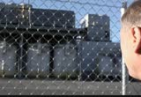
through the weekend. the beltway in bethesda looks good between 270 bradley boulevard and down into tysons corner. all lanes are open at this time and no delays to worry about. i'll be back with more traffic info coming up at 6:18. back to you guys. at 6:13. here's what's making news now. a fire continues to burn at a d.c. warehouse, this is a live look at what's left of the structure at 400 morse street. firefighters have been there all night since it began around 10:00 p.m. the fire coming from the roof and rear of the building, there is reports -- there are reports firefighters had a tough time get to the blaze because of the structure of the building. the search is underway for a man accused of setting homemade explosives at three homes on virginia. they identified the suspect 25- year-old lawrence alan stuart ii. he was targeting an ex- girlfriend and two local sheriff's deputies in the explosions and no one was hurt. new york city is in a
6:14 am

transportation emergency in the wake of hurricane sandy. new york governor andrew cuomo ordered fares for all trains, subways and buses to be free today and tomorrow. as a bay to encourage -- way to encourage people to take mass transit. i think i heard the mayor say they want all cabs to have at least three people in them as well. >> the cars coming in -- >> coming in because -- >> it should be three. >> the -- congestion on the roadways is just incredible yesterday. >> and i have a family up there in central long island. my brother-in-law goes from suffolk to nassau counties, nassau and west is where it gets bad approaching the city and the danger up there -- my mother-in-law said we don't go out at night. the lights are all out and people aren't obeying the stop sign at a dark intersection. so yeah. that's going to be that way for a while unfortunately up there. we are -- still recovering down here. and today, those even with a little bit of high water. we have a coastal flood warning until 2:00 this afternoon and this covers washington basically for the potomac river
6:15 am

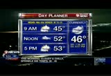
area. the tidal potomac. as we're looking at some of the tides that could be 2, maybe 2.5 feet above normal. which would be moderate flatting. at about -- flooding. at about 10:44. a little bit of flooding especially down on king street. you know the drill down there. bus stop forecast, it's cloudy and chilly once again. we have a stray sprinkle or two north and west of town. sunrise still an hour and 20 away. 7:36. going to hit daylight savings time over the weekend and be about 6:40 or so on monday. for the sunrise. our day planner, 44 at 8:00 and cloudy skies and mostly cloudy skies by noon and mostly cloudy to cloudy and 52. also a bit breezy. the winds will be westerly today at 10 to 15 and gusting to 20. high of 55 with a 4:00 p.m. temperature at 53 and still 49 at 8:00 p.m. tonight. that was a chilly halloween for the trick-or-treaters. snow in the mountains from western pennsylvania and western maryland and some areas
6:16 am
especially in maryland and even more so west virginia. i think a report out of gatlinburg with like 34 inches, we have some light sprinkles up north of town not all of this reaching the ground from the shenandoah valley back up to myersville and frederick and mount airy and thurmont. this morning your temperatures on the chilly side. 44 in ashburn. 41 in centerville this morning and 42 at andrews and as we look outside on our michael & son weather camera. good visibility and cloudy skies. windchill only 43 because thankfully our winds are relatively light at 6 miles an hour. sandy will slowly unwind and see slowly improving sky conditions. in the going to warm ill all that much. -- not going to warm up all that much with nighttime temperatures generally in the upper 30s to low 40s. to the weekend, terms are home saturday. football weather 54. clocks back saturday night so we get an extra hour of sleep. that's always a good thing. and then sunday for the skins, we have temperatures in the mid 50s. it's 6:16.
6:17 am

here comes monika samtani. timesaver traffic. lorton road at furnace road. you want to watch out for fallen power lines. and also we've been telling you all morning about a big fire in northeast at fourth and morse. that's east of gallaudet university. you want to watch out for the closures in and around that area and avoid it if you can. northbound 95 not looking too bad. 42 miles an hour. as you head up toward triangle and then again in woodbridge across the occoquan river. we'll take a live look outside show you what it looks like here in springfield and this is typical for this time of the morning. leaving route 644 to the beltway 395 beginning to see the brake lights as well right around duke street. back to the maps this time we're heading to the other side of town. no issues on the beltway. north of town. college park into silver spring looking good and 270 brake lights of course. let's take a live look there at route 109. and this is pretty much what it looks like as you leave frederick it's going off and on down to 121 before the pace improves, back with more at 6:25. back to you guys. thank you monika. it's 6:17, it's time for
6:18 am

another lookout the question of the mo -- look at the question of the morning -- >> our facebook friend jean says -- she's talking about the exorcist. >> keep posting, we'll have more of your responses and the correct answer in about 30 minutes.


6:21 am

welcome back. 6:21. your weather first on this thursday morning, like it has been the last couple of days not too windy this morning. we've got clouds and even a stray sprinkle well north and west of town. you'll need in jackets -- the jacket, upper 30s to mid 40s. a cool breezy day with plenty of clouds and temperatures struggling to get to the 50- degree mark by 11:00. a drive home temperature again a steady 53 degrees.
6:22 am

good morning everybody. robert griffin iii has shown us time and again that in his personal life, he's his very own person. he's unlike anyone else. but on the field, he's always being compared to others guys like andrew luck and michael vick and of course cam newton. well, we'll get to see them side by side this weekend. the skins return home to host the panthers and last year's rookie of the year, now rg3 obviously getting tired of the comparisons. but he says if it must be done, there are other players he'd rather be connected to. >> we do run similar schemes. you know there's a lot of similarities but you know, i don't know. i'd rather be compared to an aaron rodgers or a guy like that. somebody who's won super bowls and you want to go out there and win. that's the biggest goal here. so you know that's -- that's what this game is all about. it's not about me versus cam newton. it's about us getting the win. >> this weekend also marks the
6:23 am

redskins' 80th anniversary celebration. they will wear special june forms the and the team will also recognize the latest grown up of ten notable alumni that have been selected to join the greatest redskins. that includes guys like the late sean taylor as well as lavar arrington and this guy clinton portis. that's a quick look at sports this morning. i'm kristen berset, have a great thursday. well, when you head outside today it is still going to be breezy. a little bit cooler than yesterday. but at least some more sun. >> coming up howard and monika have your weather and traffic. [ female announcer ] now there's a way


6:26 am

to make just about anything delicious. introducing new jif chocolate flavored hazelnut spread. whatever you put it on... reaches a whole new level of deliciousness.
6:27 am

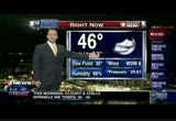
choosy moms choose jif. we're back at 6:27. this is always the place to get your weather first. here's a live look at the jefferson memorial and the temperature is a cool 46 degrees. this morning. thank you for starting your thursday with us, i'm andrea roane. >> and i'm mike hydeck. and jacket on. howard bernstein on the weather terrace is live this morning. good morning howard. >> just a jacket and gloves too. it's not just the mid 40s and lack of humidity. but it's still humid and damp out there if for me i feel it so much more it's the kind of cold that cuts through you. some areas even down into the uppers. looking at -- 30s. looking at the day planner we'll see temperatures from the 30s and 40s in tysons corner you see the lou clouds being lit up by the city lights. could be a stray shower a
6:28 am
little sprinkle in the maryland pennsylvania border right now and at 5:00 53 after hitting a high around 55 degrees. those temps they are on the brisk side it's 41 in manassas. 39 luray. 43 hagueers town and 42 at andrews with scott and the gang. windchills not terrible this morning. we had some fairly light winds about the coldest up in frederick. and as far as the radar and slight you will see the rain and snow showers in the mountains and looks a lot worse than it is actually along the maryland and pennsylvania border although there are some light sprinkles coming out of that. next time we'll salk seven day forecast -- talk seven day, if into the weekend. i just got off the phone with ddot down in d.c.. and trying to get an update on the fire that's been ongoing over at fourth and morse street northeast. east of gallaudet university. the latest information is that northbound fourth street is blocked at florida avenue
6:29 am

northeast. florida avenue itself is open. so you can access that area but i would suggest that you just avoid it with all that activity there you are bound to hit some delays there. but northbound fourth is blocked at florida avenue and anything leading top morse street there -- up to morse street there. first of all the maps, gw parkway looks great. here's the 14th street bridge, northbound the delays here and in hand landmark northbound 95 the same story from quantico and springfield just the normal slow stuff trying to get to the beltway or beyond on to 395. back over to another live picture this time we're going to goth other side of town -- go to the other side of town. this is pretty much what it looks lick on the west side between 270 tysons corner and springfield. we'll also go to another live picture this time let's take a look at 270. on the southbound side if you're planning to head southbound off and on delays out of frederick to 109. let's go back over to the graphics, some information on penn line 407 which is now
6:30 am

running 15 to 20 minutes late. i'll be back with more traffic at 6:43. back to you guys. time now to welcome the partners at "cbs this morning." >> charlie rose in new york and of course we know you are covering sandy with mass transit. electrical problems. >> you are right, you have listed the problems that we all face. trillions, power outages, disruption of property and some real alarming ways that this storm has done damage. so the latest from this program on when travel will get back to normal. also jim axelrod takes us down inside the city subway station still flooded by two stories of water. the denverration is so bad on new jersey's barrier island many residents won't be allowed back for days, but our own bensy treysy went into a hard hit area. plus jeb bush will be with us when we see you at 7:00 and
6:31 am

talk politics. >> thank you. as charlie was saying sandy menaced the east coast closing schools, markets, businesses and transit. >> and it is going to take more than a little time to recover from the wreckage. there are pledges by government officials from the white house, on down, to help overcome this devastation. the worst the atlantic storm in the nation's history. >> kristin fisher has more on that recovery effort. >> reporter: well, new york city slowly starting to show signs of life after hurricane sandy. but the city that never sleeps still in the dark and now the cloneup begins. millions of people in the dark, and they're having to clean up you know the damage caused by the wind, all the rain and perhaps most shockingly one of the most shocking side effects of hurricane sandy, the fire. the fire in breezy point where over 100 homes burned to the ground. the water and high winds whipping the coast kept the blaze raging for several hours. yesterday, some residents returned shocked by the devastation. and not knowing where to begin or what to do next.
6:32 am

>> i thought i could fight the floods. and i probably could have fought the flood. but not the fire. i couldn't have fought the fire. >> reporter: elsewhere gridlock on the streets of manhattan. mayor bloomberg is requiring a three passenger minimum for all vehicles entering certain parts of the city. three of new york's major tunnels remain closed today filled with flood waters and mud. and portions of the subway system are still submerged along a runway in laguardia airport. residents are trapped in their homes with no power and no clean water. if they try to leave they face wading in the toxic water polluted by gasoline, raw sewage and people there say the smell is just overwhelming. and all of that water will need to be pumped out. that alone could take several more days. mike, andrea back to you. >> all right, kristin fisher thank you for that update on what's happening further north in new york city. >> boy, such a tough go there. right now there are a few possibilities in our region still without power. >> here's a look at the latest
6:33 am

outage numbers for our region -- so we do have a few school closings to tell you about this morning, in anne arundel the following schools do not have power and will not have classes today -- in prince george's county -- in frederick county -- and in mineral county, west virginia -- go to our website, wusa9.com, you can see the closings and delays there. the recovery from superstorm sandy looks quite a lot different in far western maryland. that's where the one time
6:34 am

hurricane joined forces with a cold front to create bless conditions. some places in -- blizzard conditions. some plagues in garrett garrett recorded up to 3 feet of snow. the governor plans to tour the area including visiting people who are forced to stay in shelters. time now to go to julie wolf. she's on the scene of a fatal pedestrian that took the life of a 15-year-old in jermantown, maryland. obviously this is a really tough situation for people at that school. >> reporter: it really is. and when you hear people talk about 15-year-old christina morris-ward, you really feel leek you get to know her. the incident where it happened and what witnesses are saying happened. so this is the corner of wisteria and jermantown behind me. police say she was on the other side of the road there walking across jermantown made et across four lanes of traffic into the median there and was trying to cross the rest of the street here. just up the road there at seneca valley high school. she was on the way there when she was hit and killed here in the road behind me.
6:35 am
now montgomery county police tell me the driver of the car, a 27-year-old man did stop and help after the accident. he did have the green light witnesses say. it happened just after 7:00 a.m. and it was overcast and still mostly dark. she was wearing dark clothes and police believe visibility may have been an issue here. she was less than a half mile if the seneca -- from the seneca high school and the principal knows her very well and called her a shining student. he says the school is surrounded by busy roads. >> i think that's one of the responsibilities that any school has to remind our students that -- that while school is a very safe place to be, our roads are heavily traveled. heavily trafficked and early in the morning late in the evening when it starts to get dark or when the sun is just starting o come up. it's an especially good time to be cognizant of the surroundings. >> reporter: now, the conditions we're seeing here this morning very similar to
6:36 am

the conditions when this accident happened. when 15-year-old christina morris-ward was hit here. the road has some wet patches some dry patches still dark. sunrise isn't until 7:35. and you can see the lights behind me working. there was a crew working on the traffic lights yesterday just after the accident. i asked montgomery county police if these lights were in working order at the time of the accident. they tell me yes, they were. and that's why their investigators are still looking into exactly what happened in the moments leading up to the accident. in jermantown, julie wolf. 9news now. at 6:36. jessica doyle is watching your money. >> hurricane sandy has affected a lot of us, which means we have insurance claims to file and you have some help. >> we know property damage has been extensive because of hurricane sandy. property damage alone we're not talking about the economic losses but property damage is being estimated at up to $20 billion. from the flooding, the trees down, the damaged cars the damaged houses and the like.
6:37 am

half of this total is expected to be covered by insurance. so it's time to take stock of your damage at home. figure out if it's even worth it to file a claim. now first things first, you got to know what your deductible is. and usually they tend the range between $500 to $1,000. depending on your policy. also you node to know the -- need to know the claims are processed on a first come, first serve basis. if you have a lot of damage, you need to act fast, otherwise it could be weeks before you get a check. here's the paper trail you need to keep. save receipts, that means in a hotel, keep those receipts. homeowners' insurance policies generally cover the cost of additional living ebb pences if you -- expenses if you can't live in your own home. take photos of all the damage, this includes the lost food from your refrigerator because that can add up really fast. and keep every single damaged item until the adjustor has
6:38 am

visited. one last note for you many homeowners' insurance policies exclude flood damage. flood coverage is sold through specialized policies and don't assume the flooded basement is going to be covered in the situation. also if your cat got damaged due to rain or flooding being in you probably need a -- getting in you probably need a koch hencive coverage policy as well. a lot of car owners are going to find out they're just not covered for a lot of the damage at home. >> that gets expensive very quickly. >> it does, it really does. >> the fridge alone can be $150 to $200 with the lost food in there. >> thanks jess. three days after sandy, it looks like we have a little sunshine ahead in the forecast. >> sounds good doesn't it? stay with us, howard is going to have information on that and of course monika with the traffic coming up next.


6:43 am

it's -- welcome back. it's 6:42 and 46 degrees, monika here with your timesaver traffic. and you're going to see that the volumes are increasing right now. there are no major incidents on our thoroughfares coming into the beltway. happy to say except for one spot and that's northbound 95 just north of dale city an accident blocking the right lane. that's going to slow you down if you're just heading out the door remember that. also public transportation marc penn delays 407 is running 15 to 20 minutes late. a look outside show you what it looks like on the beltway north of town. this is normal. it is now after 6:30. 6:43 in the morning and you've got delays now on the outer loop westbound 495 leaving 95 past new hampshire avenue heading the georgia avenue and then the us prime you haves be -- pace improves but rest assured right now the lanes are open. i'm happy so say. back to the maps this time over to the inbound side of the dulles toll road looking fine as you come in. no problems on 66 just brake lights manassas to centreville. a live look at the 14th street bridge, want to remind you there was a pretty major fire
6:44 am

in northeast at fourth and morse street east of gallaudet university. right now northbound fourth is blocked at florida avenue. florida avenue is open. i'll be back with a look at the big picture again at 6:58. howard? >> we're anticipating the hour falling back and getting extra sleep this weekend. >> we'll take it. >> exactly. >> this is the time change weekend where the clocks foul back. the standard -- fall back. used to believe earlier in the year. i think it's working out all right for us. >> sleep whenever. >> hey weather-wise i want to share a picture with you. we've been talking about the rain and snows in the mountains this picture came in from francine reynolds in northeastern garrett county. she probably took this picture before the 30-inch report that she e-mailed us. and there's still getting a few more inches of snow up there and locally 3 feet even 40
6:45 am
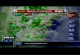
inches plus like above 4,000 feet. and an incredible epic record- breaking snowstorm in many areas. and in west virginia, those totals are likely to be state records for them. here's the bus stop forecast, temperatures the morning on the cool side into the 40s and 40s -- 30s and 40s with areas that are just dealing the stray shower north of town. we've got not too much wind which is good and plenty of clouds. so another cool, cool morning out there. you'll need the jackets. and you might need a little rain gear. there's a lot of stuff going on. we've got some mountain snows and we've got some rain in spots. here's the radar, you can see a lot of returns here. not all of this is reaching the ground. there may be a stray sprinkle south of winchester, a report here near the maryland and pennsylvania border a little bit of rain there and around mount airy a couple of sprinkles actually making it to the surface. temps in the low to mid-40s and hagerstown 434. gaithersburg is 45. but we have a couple of spots like manassas and luray right now which are reporting temperatures as cool as 39
6:46 am
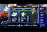
degrees. hey speaking of cool, check out this shot. from the michael & son weather camera. we're looking east out of tysons corner. some breaks in the clouds giving us some neat looking skies there there morning. feeling like 43 with the partly to mostly cloudy skies and a west southwest wind at 6. and sandy continues to spin in ontario throwing the clouds and the moisture and the cool weather down here and we're going to stay cool looks like right through the weekend herement don't look for any big temperatures changes. mid 50s tonight and upper 30s and low 40s. tomorrow 54 and breezy both today and tomorrow, gusts over 20 is what we could have. saturday and sunday look better temperatures again in the mid 50s with more sunshine. so we got home games for the terps and we've got home games for the skins, weather should be feeling like football. next week a storm may miss us out in the ocean and keep it out in the ocean with temperatures in the low 50s. switch gears now and talk about families trying to repair the damage caused by sandy extensive reboiling like the
6:47 am

can be -- rebuilding like this can be very dangerous. joining me this morning to make sure you're prepared for emergencies, this is sergeant mike force from d.c. ems. >> good morning sir how you doing? >> we want the talk about cpr because heart attacks, stress related, people are having issues and a lot of them happen at home. >> that's correct howard. >> so things have changed from the old versions of cpr to the hands-on cpr? >> that's correct. the heart association came up with a new concept and the new concept is hands only cpr. >> not blowing in the mouth anymore? >> if you're a health care professional, you're expected to do ventilations, but what they did is they decided a lot of people would not intervene with cpr. so now by you not having to do the breaths you can do compression only to circulate the blood to the heart to the brain. >> i took a course years ago and we had to do i think ten compressions and then blowing once or twice and then ten compressions but that's different. >> right, now the main imfa session is on doing good --
6:48 am

emphasis is on doing good compressions, you have to do 100 a minute. >> you have to do pretty good on that. >> you want the make sure you have a good pressure going to the heart and the brain so that way once the defibrillator arrives on the scene the either can be well primed so that way you can shock the heart. >> just give me an example of how hard i should be compressing somebody if i see them go down and i can detect they're not having a heartbeat anymore. >> get a defibrillator, the hands between the nipple line. >> the process? who know what is this is? on the sternum? >> right there in the flat part. and you can just press down. a lot of times people are thinking they're doing harm to the patient -- >> looks like you will break a rib doing that. >> the flat bone is connected to ribs here and for the most part, if you have your hand placement in a good -- you have a good rhythm you're pretty much -- do good. >> so 100 times a minute. that's pretty good pacement we
6:49 am
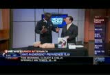
have some at home cpr rip explain to -- tips? explain this to me. >> it is called cpr anytime. you can train somebody under an hour. so what you do is you purchase the kit and you have family reunions or anything like that going on and you can train two people on average two to three people per kit. the main thing is we really want to focus on cpr anytime in schools and communities. if you train the children in the schools and they can take it back to the families and you can have the whole family trained. >> isn't a website? >> yes, it's cpranytime.org. >> you have a heart walk coming up. very involved in that. it's november 10th at nationals park. are you going on through the giving -- to be out there giving temptations as well? >> the heart association will be out there. they will have a table and doing demonstrations and basically we also d.c. fire is going to be out there in reference to making sure everyone is okay as far as safety-wise. >> if you don't thinks this important i was reading where there are twice as many heart attacks on african-americans as opposed to caucasians and four
6:50 am

out of five heart events will happen in the home. >> that's correct. and the problem is at lot of times people are not prepared and here in the district of columbia, on average our response times for the most part real good. but you still want to be trained. you know and cpr. and for the most part, that's my job in the fire department doing community outreach and making sure everyone in the city will be trained in cpr. >> if you do there you actually can save a life and make a difference. sergeant portion thanks for coming in. mike back to you. all right, howard. thank you. time now for -- autopsying the question of the -- answering the question of the day -- before we give you the answer, we want to let you know thomas wet -- wrote -- >> but, they're all pretty scary, the answer was indeed b. and we think so too "the


6:54 am
welcome back. 6:54. your weather first on this thursday morning, jacket weather again, we're 46 with cloudy skies. mostly cloudy skies. little breezy at times today. mostly cloudy to cloudy even a stray sprinkle up north. an afternoon high around 55. andrea? thank you howard. news before you two at 6:54. the northeast continues to recover from sandy with damage still being assessed the economic loss is believed to be as much as $55 billion. this morning, police continue to investigate a fatal pedestrian accident in jermantown. a 15-year-old was killed on
6:55 am

jermantown road at wisteria drive. at the point grader christina morris-ward was walking to the high school when she was hit. these are live pictures if northeast washington where a -- from northeast washington where a fear continues to burn at 400 morse street. firefighters arrived lastnitis around 10:00 p.m. the find fire coming from the roof and reroof the building. it is -- roof of the building. it is 6:55. >> one last check of weather and traffic right after this. [ harry umlaut ] that's one creamy muller.


6:58 am

[ sally umlaut ] it's greek-style yogurt. thick, scrumptious, and more protein than those regular yogurts. are those almonds i see in the corner thingy? caramelized almonds i think you'll find. well, who wants ordinary run-of-the-mill almonds when you could have the caramelized kind? if i was this girl, i'd caramelize my whole apartment. weird. this greek style yogurt has style. you can say that again. why thank you. this greek style yogurt has style. okay. stop saying it now. you're sending me mixed messages. [ male announcer ] muller. the european for yummy. well, we're looking cool and breezy again today. stray shower north this morning with lots of clouds and a few sunny weeks, and mid 350s into the weekend -- 50s into the weekend. don't forget clocks back saturday night into sunday morning. monika? we're going to go live to the sky 9 on the northbound side of i-95.
6:59 am

prince william parkway right here the accident is cleared. now two miles of delays and be aware of that. then heading into the district i was on the phone with dd again. they tell me northbound fourth street is still blocked in northeast at florida avenue. that's basically the main entrance into the market area. where we've been told to move out a major fire at fourth and morse northeast east of gallaudet university. remember that. here on the beltway outer loop is slow 95 to georgia. a vehicle fire westbound route 350 at route 424. and monika one of the weather watchers is in fauquier county. still some roads closed in the rural areas and just keep that in mind going out and about. >> "cbs this morning" is next. the havoc caused by sandy and take a look at recovery efforts on the east coast after the hurricane. >> howard and i will be back in 25 minutes with another live update on weather and traffic. >> get updates on wusa9.com. >> see you back here tomorrow morning. 4:25.
205 Views
IN COLLECTIONS
WUSA (CBS) Television Archive
  Television Archive News Search Service
Uploaded by TV Archive on
